Spots
Activity
SOTA
WWFF
POTA
SiOTA
HEMA
ZLOTA
KRMNPA
SANPCPA
SHIRES
BOTA
QRP
Tools
Tools
Parks
Peaks
Maps
Alerts
History
Help
Search
Username
Password
Active Blogs
VK1AD
VK1DI
VK5PAS
VK Groups
VKCW.net
Slow CW Net
VK QRP Club
OZSOTA
SOTA VK1
KRMNPA
SANPCPA
WWFF
Applications
iOS ParknPeaks App.
VK port-a-log.
Links
VK SOTA Calendar.
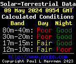
Space Weather.
SOTAWatch.
SOTA Mapping Project.
APRS Location
VK2FMIA
VK2GEL
VK2IO
VK2JNG
VK2MG
VK2XSE
VK3ARH
VK3CAT
VK3IL
VK3OHM
VK3TKK
VK3SRC
VK3YY
VK5CZ
VK5HSX
VK5LY
VK6MMB